18.3 miles, via Humberstone, Barkby, Queniborough, Gaddesby, Ashby Folville, Barsby,
South Croxton, Hungarton, Keyham & Scraptoft.
Down to Leicestershire for a week, to get away from the stresses of work and the celebrate My Dad's birthday, 74 and counting, and whilst staying with My Parents for some unwinding, it makes sense not rest on my laurels and to venture into the Old Country once again, and my tour of two years ago took me in search of the lost villages in the east of the county, so this time around it makes sense to go looking at the ones that are still there.
An early start then, setting out from the family pile at 9.05am, with the first port of call being Humberstone village, a mile or so distant, where I was schooled and one of only two villages to have been consumed by the City of Leicester, a centre that doesn't have a great deal to suggest much history before the 20th century to the casual eye, but the church of St Mary has medieval fragments hidden by aggressive Victorian restoration, and there's a single thatched cottage and section of cob wall present too, and the Humberstone Grange hides behind high walls concealing its ancientness. The Old Humberstone conservation area has done much to preserve its antiquity, and a trip down memory lane continues as I press out of the village down Main Street and Gipsy Lane, past the Tithe barn and up Thurmaston Lane on the way past Manor Farm. The A563 ring road severs that track and what was once all fields has no become the Hamilton estate, grown in the last two decades but providing green corridors for those who find late 20th residential developments objectionable, and also a cycling circuit and a lake to give the area a useful lung, which is quite surprising to me. Passage north turns out to be clearer than I'd expected, good surfaces leading to Barkby Thorpe lane, and then striking out to a field track through peas and wheat, getting good views across the city and over to Charnwood forest. Press on a good pace to arrive in Barkby, a village with brutal corners and a forge that is still active, with the spired church of St Mary looming over it in the local style of ironstone and ashlar, then onwards past the cricket ground, and 'the dangerous trees', and up Barkby Holt Lane to find the path that hits the field boundaries on the long walk in the direction of Queniborough. Initially easy going among wheat and oats, then slightly more challenging through fields of calves and drying rapeseed, but the spire of the parish church offers sight of our destination before the passage through equestrian fields provides the most puzzlement of the day. Old Queniborough is gorgeous, not to be confused with the newer settlement to the west, a riot of thatch and 18th century farmsteads, with its pair of hostelries providing a very short pub crawl, and the church being atypically built of red sandstone with its spire being clearly a later addition, dedicated to St Mary, as if no one in this county had the slightest shred of imagination.
Depart by the brick dovecote, beautifully restored, pass over the brook and start the long field walk of multiple miles, setting out uphill through cow pasture, cresting the hill to a view into the valley of Gaddesby Brook, only one channel down from the River Wreake, moving on for more than an hour through sheep fields, wheat and hay meadows, grazing cattle and horses at the valley floor, shadowing through plantations of trees and marginal grasslands before winding up on the Anglings farm nurseries, where plants for your DIY superstore are grown outdoors in many, many plant pots. Move on past the fishing lake and finally cross over the brook, making my way across the cricket field and into Gaddesby village, notable as home of the Cheney Arms and the post office which once had its entire manifest posted in its window, and my path takes me past the common in the middle of the village and up to the churchyard, for lunch in the shadow of the ornately carved and well dressed parish church of St Luke (hurrah for variety, finally). Away from the village rapidly, meeting the Leicestershire Round path (100+ miles, and unlikely to get on my schedule soon), wandering among the fields of wheat and rapeseed, with the best view coming across the pastures towards Mill Farm, and all told Ashby Folville seems further away than I was expecting. Farmsteads cluster on Highfield road but there isn't a great deal to the village, very few residences to serve The Carington Arms, the cricket field and the church of, you've guessed it, St Mary. To me it will always be noted for its zebra-striped and chequer-boarded bridges, but no lingering today as we have to head on to the homeward stretch, passing back across Gaddesby brook and hitting the uphill stretch through the sheep pastures in the direction of Barsby, really not very far away after the miles of fields in the early going. For a notional hamlet, it's a lot bigger than the preceding village, though its most notable feature is not seen from my path, the pub called William IV, whom most passers-by can't immediately place in the list of British monarchs (1830-7, if you were wondering). Another short walk follows, managing some considerable down and up in a very short distance among fields of sheep, horses and natural burials on the way up to South Croxton which I will always judge as one of the best situated villages in the county.
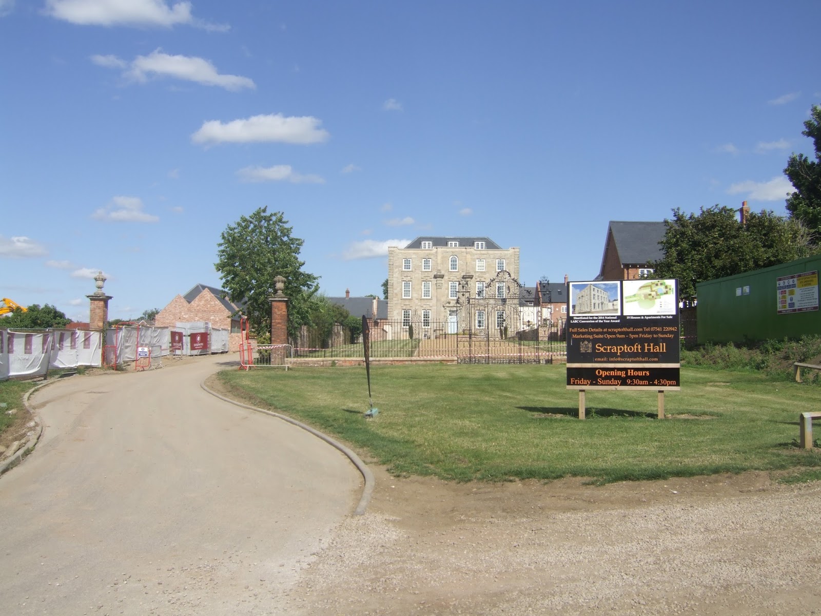
With the church of St John the Baptist at the top, spired and prominent, with village spread down along the lane descending to the south, it really scores picturesque point that haven't been lost with the more recent decades of redevelopment, and I recall the Golden Fleece as a pretty decent restaurant too, all looking grand in the warm sunshine. There's still plenty of miles to go, so hit the path over to the crossing of Queniborough Brook, and the long field walk uphill to New Covert plantation and around Waterloo Lodge farm, crossing the lost villages trail and striking off on a level track across more fields and around an excessively made over farm development to meet Baggrave Road just outside the village of Hungarton, where the Black Boy is its well advertised public house. The village is well concealed by the landscape folds, the church of St John the Baptist (yay, duplication) hiding well even with its tall knobbly spire, and the path onwards leads from Cobaulk Road and across a level track through the fields, giving us one of the few views we get towards Billesdon Coplow, before meeting Hungarton Lane and passing over the ancient Keyham Bridge and up past the village churchyard, quite a distance outside its perimeter, then detour via an equestrian field up to Ingarsby Road and into Keyham itself. This one is even more of a cul de sac, the modestly scaled All Saints church adding a quaintness to a village that has really resisted contemporary development, the centre still feeling 19thy century, the pub, the Dog and Gun, is one I would really rate). Afternoon heat means enthusiasm drops, but press on as the track drops and rises sharply on a path through the fields of oats and wheat, the end of this county looking a lovely rustic colour, and the most confusing part of the day comes when the old Leicester Poly sports fields present themselves with no obvious ongoing path. Beyond, the site of Scraptoft campus, where my Mum did teacher training, has gone, now redeveloping residentially in a particularly gross style, and that's the story of Scraptoft village, outside the city boundary but barely having any life as an independent entity. At least Scraptoft Hall is getting revived after far too many years on the Building at Risk register, and no amount of contemporary growth can spoil the situation of the squat and bulky All Saints church (what is it with all the duplicated dedications?), and last port of call will be The White House, a long term terrible restaurant that has new life as a Wetherspoons, a good place for a reviving drink before the final push back to base, a mile or so distant, for a 4.40pm finish.
5,000 Miles Cumulative Total: 1793.5 miles
2015 Cumulative Total: 391.3 miles
Up Country Total: 1648.8 miles
Solo Total: 1581.5 miles
 |
| St Mary's church, Humberstone. |
 |
| Hamilton Estate Lake. |
 |
| The View of the City of Leicester. |
 |
| Barkby, and St Mary's church. |
 |
| The View to Charnwood Forest. |
 |
| Queniborough, and St Mary's Church. |
 |
| The view over Gaddesby Brook, towards the Wreake Valley. |
 |
| Anglings Farm Nurseries. |
 |
| St Luke's church, Gaddesby. |
 |
| Mill Farm. |
 |
| St Mary's church, Ashby Folville. |
 |
| Barsby. |
 |
| South Croxton, and St John the Baptist's church. |
 |
| New Covert Plantation. |
 |
| Hungarton. |
 |
| Keyham. |
 |
| Bucolic colours in East Leicestershire. |
 |
| Scraptoft Hall. |
Next Up: My first Reservoir Walk in a long time, and in a new county to boot!


No comments:
Post a Comment