14 miles, via Walton, Wighill, Healaugh, Angram, Askham Richard, Askham Bryan,
Foxwood, Hob Moor & Holgate.
Saturday gets dumped from the schedule as the risk of afternoon rain looks too high, and I'd prefer a lie in anyway, and so my walk has to be planned for Sunday, which means making a connection for the 771 bus with as small a margin for error as is possible, but it all comes good, despite the bus riding taking forever to get out to the top right corner of West Yorkshire. So we start out from the Pax Inn in Thorpe Arch after 10.25am, again falling for this village in the bright sunshine, and as we are a little off track on our long route to York, we need to make a path back to Walton before we are on the correct course, and that means heading south to join Church Causeway at its bottom end and then striking the path to the north to meet All Saints church, sat proudly apart from the village and brightly illuminated. Heading north we can complete the loop around Thorpe Arch and pass the railway alignment once again, and then carrying on past HMP Wealstun, and is that the first prison to drop onto my walking plan since New Hall in darkest Wakefield district? This one looks more the part, though modern prisons ought to have the crenellations of their Victorian counterparts just to keep up appearances, and I'm not sure if it's the sort of place I ought to be photographing extensively, and it's presence makes the housing developments of Thorpe Arch Grange and Walton just that bit less appealing. Still, our focus can look East as we hit Wighill Lane, to skirt our way around the TATE, and the well secured boundaries of the British Library and the vehicle testing centre, taking care with the blind corners and getting a last look at the hidden bunkers of the ROF site, and also taking interest in the path of the Roman road Rudgate as it reappears on the north side of the Wharfe, cutting its path in the direction of Boroughbridge.
Carry on into North Yorkshire, with lots of cyclists for company, slightly frustrated that there's so little to pick out in the landscape to the south, aside from the chimneys of Tadcaster, and attention is drawn to Wighill as it comes on in the landscape, with All Saints church featured prominently at its south end. A jaunt into the churchyard is worth while before passing Brook hall and the haphazard accumulation of 20th century houses on its southern side, but the north side brings out the best of Wighill, plenty of familiar styled houses in rough brick, located around the White Swan, located too early in the day for a sneaky carvery visit. Straightforward pathfinding among the villages of the Ainsty should hopefully be the order of the day, as this flatland between the Wharfe, Nidd and Ouse ought to offer few challenges to speedy going as there will be few rises above the 20m contour, and so goes Wighill Lane in the direction of New Buildings farm, where a corner can be cut off by taking a field walk. The rough pasture makes it feel like it might not be a shortcut at all, but the going is clearer as we skirt Dews Wood and try not to disturb the cattle in sheep in the enclosed fields on the way over to Healaugh, where a confusing passage through the farm's paddock could get you feeling very lost before arriving at the bottom of the village. This is a site to admire, looking like an estate village built all in one go in the early 19th century as every house is red brick and similarly styled, and its a good spot to enjoy lunch on a convenient bench, as a local family picnic in the garden behind the hedge. Move on, as one cannot loiter on a Sunday, and hit York Road, to meet the farm that shares its name, and fun can be had with a game of spot the building style in the long wall of the barn, as every repair and extension seems to have made in a completely different fashion over the years, I can count eight, if you're bothered.
Not a lot to see beyond the many hedges so attention is given to finding the bridleway across The Bogs, and elevated causeway across the field is clear going until it moves into a different parish and gets rather more overgrown before meeting New Lane to provide a clearer track, albeit one with many kinks in the direction of Angram. Now here's a hamlet to visit only because it would otherwise be a name on the map otherwise unseen, and the only sights here are one grand barn and one house with a very odd sounding burglar alarm, and that's all there is to see so attention move to carrying on to Askham Richard, soon spotted as a tall house and tower rise above the village, and puzzling out their identity will keep you interested as you count the corners of the road until School Lane draws you into the village. Turns out this is Askham Grange, now part of the HMP Askham Grange site, looking like something that Norman Shaw would have built in the late 19th century, with its style bleeding into the surrounding houses, making it one of the more improbable prisons to find (and our second for today), and the village beyond seems to be a lot more conventional, ranged around its large duckpond. It's busy too, but I can't imagine it's just because people want to come here to feed the ducks and drink in the Rose & Crown, I'm guessing that it's visiting hours at the gaol and folks are happy enough to make a day out of it. The path from Richard to Bryan is cross country, on former lawns behind the grange and along the field boundaries adjacent to the massive complex of Home farm, and it's less than a mile a way that Askham Bryan is found, also displaying the vernacular style, but not winning prizes for apparent desirability only because the day's sunshine has passed to make it all rather gloomy. Still, praise is needed for whoever has saved these villages from the sprawl that has consumed Copmanthorpe and Bishopthorpe, and the best relic of all is to be found here too, the late Norman church of St Nicholas, a delightful little chapel easily as good as the one in Adel, and you should already know just how much I love that one.
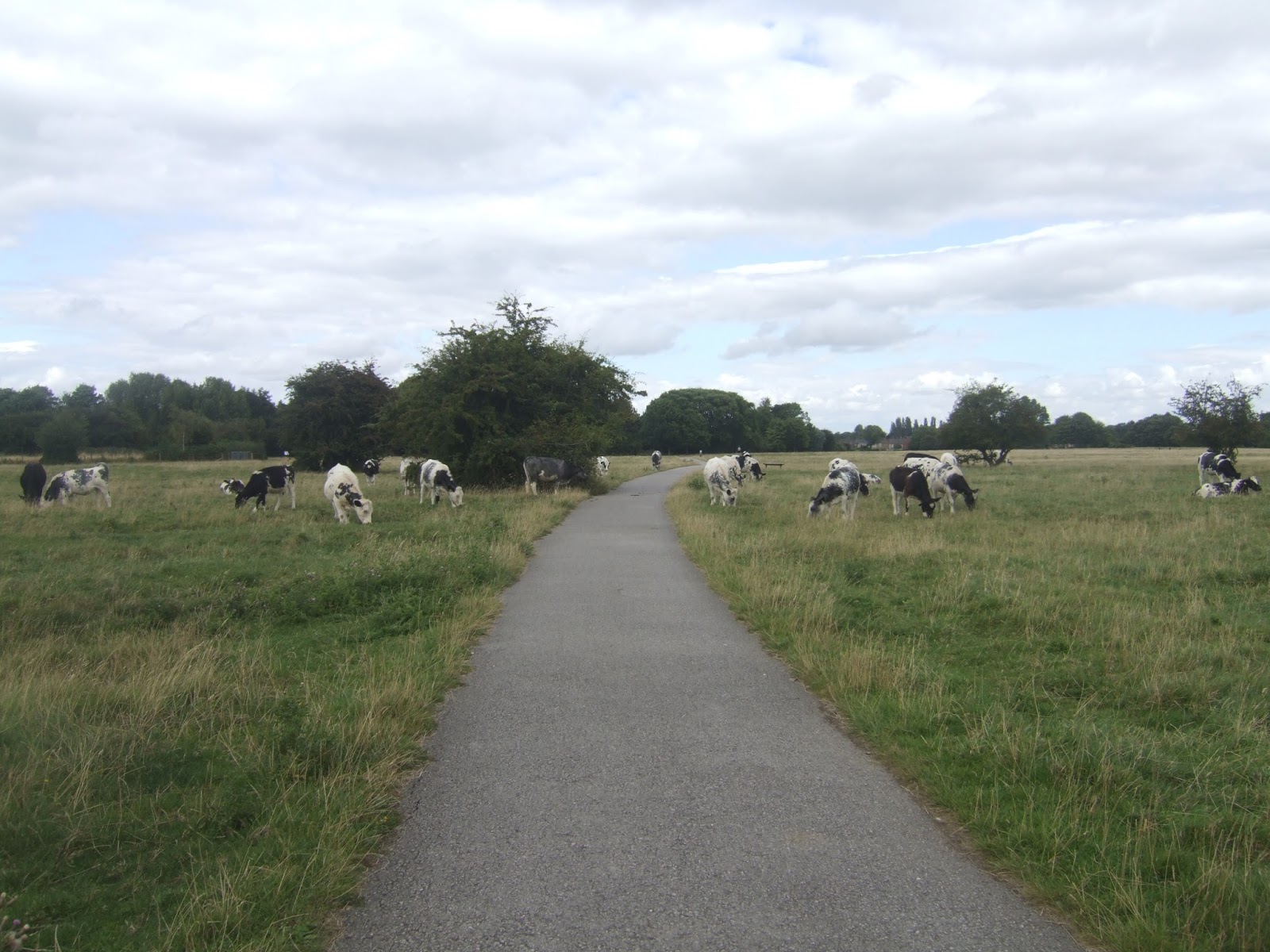
Press on as a hint of York is gained on the horizon, pondering who Richard and Bryan might have been, arriving on the stretch of Askham Lane severed by the A1237 ring road, soon met and crossed before catching a great view over the distant city, with the lane continuing off to the north-east, and despite this becoming a cyclist friendly city, it's not being too kind the walkers, doing little more than providing a wide verge to pace. The suburban city is found beyond the 30m rise of Great Knoll, and after finding the pretty and historical routes into York on my previous travels, this one along Foxwood Lane providing the vintage and style of suburbia that I probably hate the most, the kind that could be found in any city in any part of this island, but hey, all faces of our cities ought to be acknowledged, shouldn't they? Relief comes on as playing field replace the houses, and over Thanet Road, the cycleway carries onto the eastern perimeter of Hob Moor, a large field of rough common land that endures between the council estate and the railway, where the most docile cows are left to graze and the wildness isn't spoiled by a housing development having gone up on the former school site that had encroached onto it. A terrific space, albeit on that isn't too easy to find your way out of, but paths lead into the earlier suburbia of Holgate, and the way up Holly Bank Road and Hamilton Drive East are not nearly as unpleasant as Foxwood, aesthetically, though what you really want to see in York is the Georgian terraces and villas, and they can be found on the A59 Holgate Road, looking as grand as ever. A Victorian juxtaposition can be found with the gothic St Paul's church next to Holgate Road bridge, the massive box girder construction known to any trainspotter that has done time in York (and we are many) but one I've never travelled over in all my years, and then it's back to the terraces on the lead in to Blossom Street. The last leg takes us past the Crescent, the Reel cinema (in proud Odeon style), and our look at the exterior view of Micklegate Bar that I had promised the last time I came this way, and thence it's on to the station, to take in the Railwayman's institute, the NER Goods Sheds and the Old Station approach before making my arrival at 3.25pm, a whole 45 minutes ahead of schedule, confirming my belief that this would be a good day for speed.
5,000 Miles Cumulative Total: 2397.3 miles
2016 Total: 382.9 miles
Up Country Total: 2181.8 miles
Solo Total: 2166.4 miles
 |
| All Saints Thorpe Arch, glowing and peaceful on a Sunday Morning. |
 |
| HMP Wealstun, in dire need of thick walls and battlements, no? |
 |
| Rudgate, the Roman Red Route to Boroughbridge. |
 |
| Wighill, and I love every single building in the Ainsty that looks like this. |
 |
| Dews Wood and what passes for challenging going in the Ainsty. |
 |
| Healaugh, and every village should be as well composed as this one. |
 |
| The Bogs Causeway, clear going until an assault by prickly bushes happens. |
 |
| Sycamore Barn, Angram, the most interesting building in the hamlet. |
 |
Askham Richard providing a pleasant and idyllic setting for
the people who've come to visit HMP Askham Grange. |
 |
| Home Farm, betwixt Richard and Bryan. |
 |
St Nicholas's church, Askham Bryan, easily one of the
best Norman churches to be found anywhere, a Gem. |
 |
| By the York Ring Road, the inevitable distant view of the Minster happens. |
 |
| Foxwood, I do not like this sort of Suburbia, at all. |
 |
| Hob Moor, common land in the City, with super docile cows. |
 |
| Holgate Road bridge, and you've got to love Victorian over-engineering. |
 |
| Micklegate Bar, the southern entrance to York, promised to you, and delivered. |
Next Up: A Bank Holiday walk in the Park (or two)!


No comments:
Post a Comment