14.2 miles, via Cayton, Shaw Mills, Woodfield Mill, Brimham Lodge, Brimham Moor,
Smelthouses, White Houses, Blazefield, and Knott.
 |
Long Distance Trail means Selfies!
#1 at The Market Cross, Ripley. |
'One does not simply walk into Nidderdale.' I remarked a few years back, rather dryly, and that still seems to be the case in 2017, as Spring Jollies roll around again, and I have to rely on the Parental taxi to drive me out to this most hidden of Yorkshire's dales, not much above an hour's ride away from home but a real challenge to access on foot or by public transport. So here we set ourselves up at Bewerley Hall farm, in Barn Owl Cottage, just across the river Nidd from Pateley Bridge, a nicely spacious let that might be comfortable for us all, especially for My Dad as his mobility issues have not improved over the last year, with the next Long Distance Trail on the slate, selected as it is the closest available path to home, straightforwardly do-able without requiring My Mum to put in hours of driving on my behalf. After bedding in on Saturday, our trail can get going from Ripley, at the easternmost extremity of the trail, and only a few miles distant from Harrogate to remind us that we really aren't all that far from home, getting dropped off among a tonne of visitors arriving for an equestrian event in the castle grounds, at a rather early hour on a Sunday Morning. Pick up the path at 9.55am by the Medieval cross in the village square, which with the castle and church, is one of the few ancient survivals in a village that was completely rebuilt in the early 19th century by the Lords of the Manor, the Ingilbys, after the fashion of an Alsatian village, apparently, complete with an Hotel de Ville, and thus looking like a slightly more Gothic variant on Harewood to my eyes. Main Street leads us to the B6165, telling us that its less than 10 miles to Pateley Bridge from the A61 roundabout, but naturally this trail will be finding us more miles to do as we soon head off into a bucolic landscape along Birthwaite Lane, rising past the farm and barn that share its name, before moving onto a rougher track that follows the field edge and offers faint glimpses across the Vale of York before slipping in to the woods above Cayton Gill.
 |
| The Hotel de Ville and Main Street, Ripley. |
 |
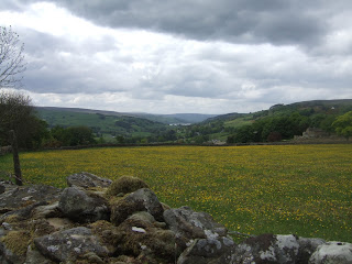
| Descending to Cayton Gill. |
A bench offers a viewpoint, entirely notional as it is currently completely shrouded by trees, before we slip down to the valley floor, which is thick with young sheep, rising across to the other side to not gain any further views east, before slipping down again through a tree-covered bluebell carpet, and meeting the surviving lumps and depressions in the landscape that used to form the lost village of Cayton. Returning to the Gill, we continue north along the edge of a marshy valley that used to be home to fishponds tended by the monks of Fountains Abbey, only 5 or so miles from here, meeting the top and passing through the wood and over the beck that was missed on the previous transit, and then rising above the planation on another decent track, setting a course westwards at long, and getting sight of Sawley Hall, far off to the north. The way into Nidderdale is set as we meet the road by Scarah Hill house, following the bank downhill on the roadside verge, dodging the traffic and piles of rock salt, before turning west on the drive to Low Kettlespring farm, looking over the depression of Thornton beck to the hamlet of Bedlam, sat on the main road into Nidderdale, and also back towards Harrogate, peeking above the trees, rising along to the farm, still an active piggery with a charming cottage hidden behind it. Pass through the wood beyond, past the former quarry and up to the muddy track below High Kettlespring farm, following the path that has been carved up by far too much cattle traffic, dropping downhill to field walk and passing among heaps of dirt and a parked bulldozer that suggest that even the farmer thinks his path might be beyond the pale. Pause for an early lunch, and to repack my bag (my new bag, purchased in January, is finally being pressed into service!), reading up on some local history before we move on, the village we developed in 1805, to service the 1787 High Mill, which with conversion of the Low Mill from corn milling in 1812, created a major industrial centre for the production of flax in the 19th century, leaving a particularly picturesque village in its wake. The Low Mill has been residentially redeveloped as a brownfield site, but has been done about as sympathetically as possible, with good view across its site being had as we hit the driveway up to Cowgate farm on the far side of the beck, rising to spot High Mill hidden away among the trees further up from the village, before turning around the farm and continuing the field walk westwards.
 |
| The lumps and depressions of Cayton (lost). |
 |
Cayton Gill, worthy of a crazy detour.
|
 |
The Road to Bedlam, and Nidderdale.
|
 |
| The valley of Thornton Beck |
 |
Shaw Mills, home of Nidderdale's Flax industry.
|
It's a good field walk, making you wish we had some skies set brighter than overcast as we press on along the valley of Thornton Beck, passing along to the side of Trustee Wood before dropping through another field of sheep and lambs to get closer to the watercourse, following its edge behind a substantial wall before crossing over a footbridge and ascending the field edge up past Black House, which has seen extensive residential rebuilding and seems to have its own golf course in its grounds. The driveway beyond offers a hard surface once again, away towards the farm lanes that litter, this corner of the valley, finding that the extensive greenhouses at High Hollins farm are actually a mass of solar panels, and taking a left turn to head us off towards Brimham Moor, peeking its heather clad top over the horizon, but we've still got some distance to go to get there, seeing that the much closer Brimham Lodge also appears to be on the same distant hillside. Before then we have Woodfield Mill to pass, declared as derelict by the route guide, but as that is 25+ years out of date, the buildings have had an executive makeover to make it perhaps the most desirable residence encountered on the trail so far, the rote passing around it via the driveway to Woodfield House and farm, followed up hill as the bridleway on the map vanishes from the ground. Head down to another crossing of the beck, and it seems that the path is closed to facilitate bridge repairs, but a long detour is out of the question and there's no one around to challenge my passage as I ignore the signage, easily crossing over and hitting the rising path beyond on the field boundaries, some of it horribly carved up by farm vehicles before alighting on the lane to Park House farm. Take the muddy track into the woods to the south, rising among the farming debris and mature trees that shelter the northern side of Brimham Lodge, and impressive 1660s dated, three storey farmhouse that was once the main agricultural centre for the nearby Brimham Hall, now a noted cattle farm with a bold aspect and many, many antennae on its front lawn, primary des-res on the trail is immediately transferred to this property. Follow the lane away to meet the Monk Wall path, heading northwards, once marking the boundary of the estate of Fountains Abbey, and possibly still extant below the high wall atop the old foundations, a track that passes above what I'm sure is an ROC nuclear monitoring bunker, whilst finally giving us our view across the Vale of York to the distant elevations of the North York Moors, the Howardian Hills and the Wolds off to the east, the eagle eyed will also confirm York Minster, further to the south than you might expect.
 |
| Above Thorton Beck, our early season companion. |
 |
| Westfield Mill, for upscale country life. |
 |
| Last Crossing of Thornton Beck, where 'None Shall Pass' apparently. |
 |
| Brimham Lodge and its baffling array of antennae. |
 |
| The Monk Wall path, giving us views to the east, at long last. |
Attention then turns to Brimham Moor, hiding away to the west, the coming moorland elevation indicated by the clumps of gorse that cluster by the sides of the path before we take our decisive turn towards it, on the driveway to Riva Hill House farm, passing its fragrant silage store before hitting the rough path that leads over to the National Trust's estate that has preserved the moorland in its best possible condition. Attention is drawn off to the elevated hilltop to the north, with the wind and water carved Gritstone formations along its boundary, pretty impressive even at this distance, though all the most popular sections of Brimham Rocks are on the western side, not visible from here as we pass on a clear track through the rough grass and heather, despite us being barely above 250m at any point on the moorland. Tag the day with a moorland walk anyway as we meet Brimham Rocks road, the way to the only place I'd previously been in Nidderdale (back in 2011 when My Parents were still apt to cover rough ground, thankfully), heading on the rise southwards to the edge of the estate to get clear sight to the listening station at RAF Menwith Hill, the mast above the Washburn and to the grey lump beyond that must be Rombalds Moor, another reminder that we really aren't all that far from West Yorkshire, and home, whilst up here. A westward turn gives us an elevated view to the dramatic reveal of Nidderdale proper, looking to the mast above Guise Cliffs, high above the southern side, and onwards to the high moorlands beyond that stretch all the way across to Upper Wharfedale, starting a descent away from the gritstone outcrops on the southern edge of Brimham Rocks and down a rather vague path in the woods, easily distracted by the return of the bluebell carpet and a second Nidderdale reveal as we descend, also getting a view to the high north side, where I'm pretty certain our path will eventually be headed. A clearer path develops as we descend to the lovely little cluster of houses around Low Wood house, dropping down to the steep lane that leads into the hamlet of Smelthouses, a name which indicates a history of lead mining, which dates back locally to the 14th century, but more notable as where the industry of Flax milling was originally established in the dale in the late 18th century. These days there's no trace of that in the village centre since the mill has gone, with the older houses having had an executive makeover and the valley downstream of Fell Beck has attracted a rash of suburban retreats in this out of the way corner of North Yorkshire, though a turn up the beck's wooded valley proves that the local industrial history is still there to be found by the keen eyed.
 |
| Brimham Moor, and the less impressive side of NT Brimham Rocks. |
 |
| The Way south to Menwith Hill, the Washburn and Rombalds Moor. |
 |
| Nidderdale reveal #1, Guise Cliffs and the high moors of Wharfedale. |
 |
| Nidderdale reveal #2, the crags on the north side. |
 |
| Smelthouses, where Lead and Flax once ruled and suburbia now dwells. |
The path might feel like it is squeezed behind someone's back garden, but the huge stone retaining walls are suggestive of a previous industrial incarnation, and as the valley of Fell Beck opens out, the former existence of numerous mill ponds at the valley floor is in evidence, despite the tree cover, the path maintaining a pretty rough but level course above the roaring stream, gradually working closer to the watercourse as the valley is ascended. As we get closer to the water's edge the path gets a bit more tenuous, a bit to close to the charging rapids in places, showing up signs of water management as we go, with the remains of weirs and sluices in among the riffles and pools, and there are also odd brick blockhouses along the way too, some relating to the beck and others appearing to cover adits and shafts dug into the rock faces, as there must surely be plenty remaining from an industry that dug and smelted lead here for several centuries. All this interest has me neglecting the path route, and I'm pretty sure deviations have been taken after crossing the beck and drifting away from its eastern bank, and after all the excellent signage on other parts of the trail, there are no markers to be found here beneath the foliage, so after rising to the brief open space around a small farmstead, it proves easier to follow another couple of walkers to find the quickest route to Fell Beck mill and the western side. This corn and flax mill has been redeveloped beyond recognition since its closure half a century ago, having even lost its millponds which would have been a useful landscape indicator, and the rise away gives us our first signs since Smelthouses, rising up across a field where a local workman is installing fence posts and misidentifying me as a man armed with a bit hammer. The pull up to the high path seen a couple of miles back is most unwelcome, but does at least offer a couple of fine views over to the western edge of Brimham Moor, where most of the rock formations are shrouded by trees, and a look south reveals RAF Menwith Hill basking in the sunshine, whilst we hit the residential level at the north side's spring line by Dougill House, gaining a pretty level track at 200m up as it swings back into the main valley. Gorse is our companion on the high path around to the cluster of farmsteads at White Houses, which offers a bench where I might devour the remainder of my rations and sink a lot of liquid before the final push, with more bushes along the path below the elevated rough crag on the northern edge as we push on westwards, looking forwards to Guise cliffs again, now a lot closer to trail off the south, as all views out of Nidderdale finally retreat.
 |
| Industrial remnants along Fell Beck. |
 |
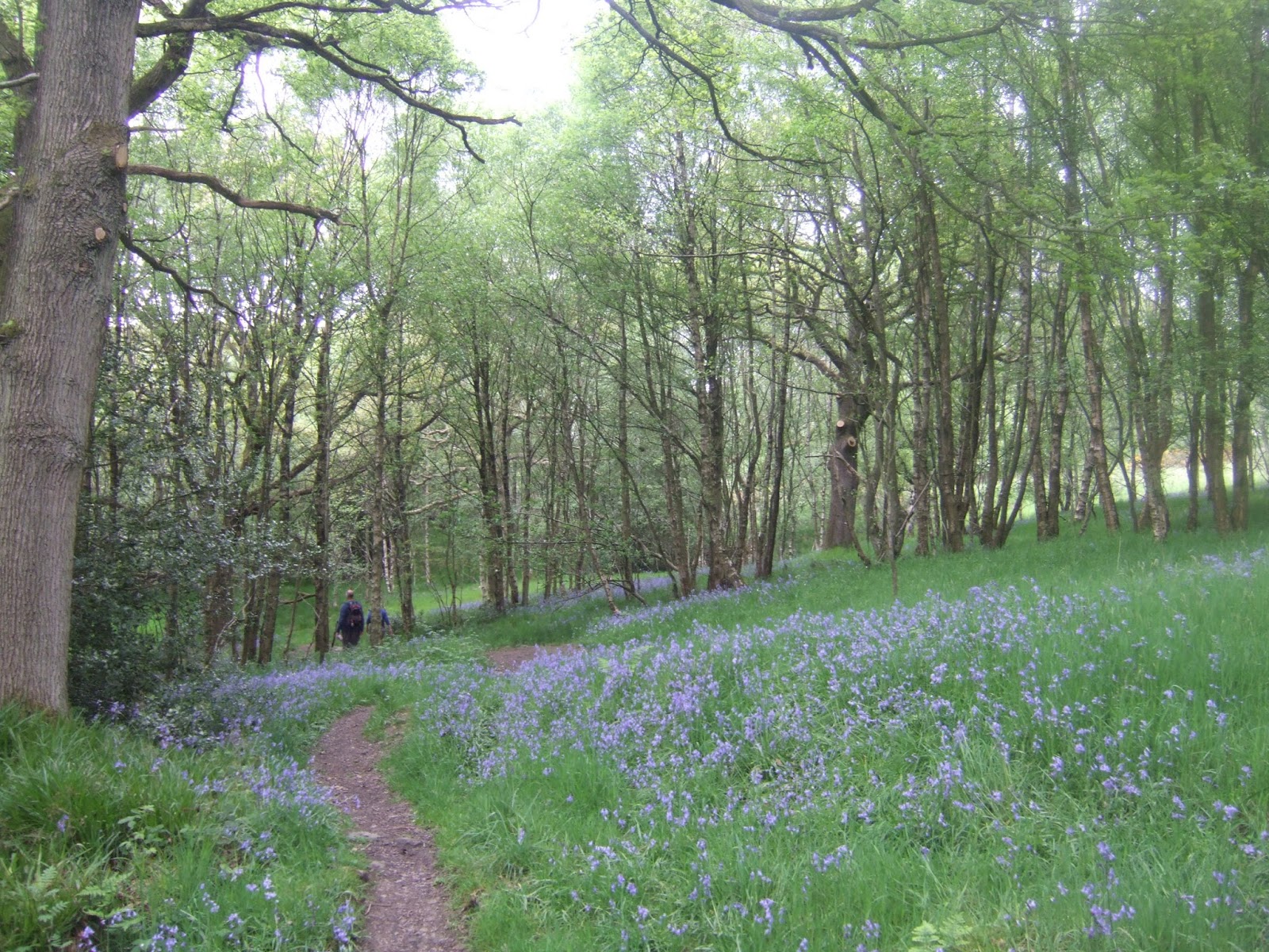
| Bluebells in the Woods, seeking the right path forwards. |
 |
| Looking Back to Brimham Rocks, they're in there, somewhere! |
 |
| Along the rough edge of the north side of Nidderdale. |
What you don't expect to find out in this corner of the world is llama farming, especially not the kind of place like Nidderdale Llamas, which touts the healthy and therapeutic benefits of taking their beasts out trekking, as if that's something that would instantly spring into the mind of your average tourist, and I'd hoped we were done with ascents for the day as we drop out of The Raikes road, but there a short pull up a double chevroned section to return to the high path, somewhat annoyingly. Roll along the road and into the house cluster at Blazefield, that is a bit more than your average hamlet, having a long terrace of houses that must be noted for their views across the valley to Guise Cliffs and the southern portion of the dale, and despite being roughly above Glasshouses down at the valley bottom, we still haven't had sight of Pateley Bridge, only a single map fold distant. Meet the B6265 Blazefield Bank, but even that doesn't take us down to the town, as we detour up, again, onto the Panorama Walk, initially under the shade of trees before giving us views again as we rise up past Hole House with its own quarry in its back yard, pushing on to the farm and house cluster at Knott, where the entirely sensible name of the path is revealed, as we can look down into the valley to reveal that Bewerley Hall farm is straight down below us, and a view emerges to the northern end of the dale, across the meadows to Gouthwaite reservoir and to the moors and high hills above the valley head. Store that up for the next day though, as the path declines, finally giving us a sight to Pateley Bridge, passing the cemetery that has grown around the church of St Mary, which must surely have been the site of the lost Medieval village of Patleia, the deep cut of the path then descending sharply among many vintages of housing before suddenly dropping us out onto Ripon Road by the Methodist church. The home straight appears so quickly, and the town still looks dressed up for the visit of this year's Tour de Yorkshire, which passed through on May Day weekend, with even St Cuthbert's church wearing a colourful bicycle, and then it's on down the High Street, patriotically dressed up to celebrate its status as Britain's Best (Village Category) for 2016. Descend, noting the oldest buildings as 1660s vintage, and it's a lovely spot to see, especially on a quiet Sunday afternoon, it will surely warrant a further examination, but for now we will finally approach the riverside, pausing by the Nidderdale Way start and finish line, incorrectly placed at the middle of the valley, in my mind, to stop with the Nidd still unseen, calling in the Parental Taxi for the short ride back to base, after an frustratingly late 4.30pm finish.
 |
| Guise Cliffs and mast, about as close as we'll get from the North side. |
 |
| Blazefield's terrace with superb views from the spring line. |
 |
| Knott, high above Pateley Bridge, which still hides from view. |
 |
| The view forward, a sneak peak to Gouthwaite Reservoir and the moors beyond. |
 |
| Pateley Bridge High Street, Nidderdale's sole town is dressed up to the nines. |
5,000 Miles Cumulative Total: 2751.5 miles
2017 Total: 186.5 miles
Up Country Total: 2507.2 miles
Solo Total: 2496.2 miles
Next Up: Onwards to the head of Nidderdale, and a place I've wanted to see for 20+ years.


No comments:
Post a Comment