8.9 miles, via Thwaites Brow, Transfield Top, Druid's Altar, Bingley, Eldwick,
and Baildon Moor, Hill & Bank.
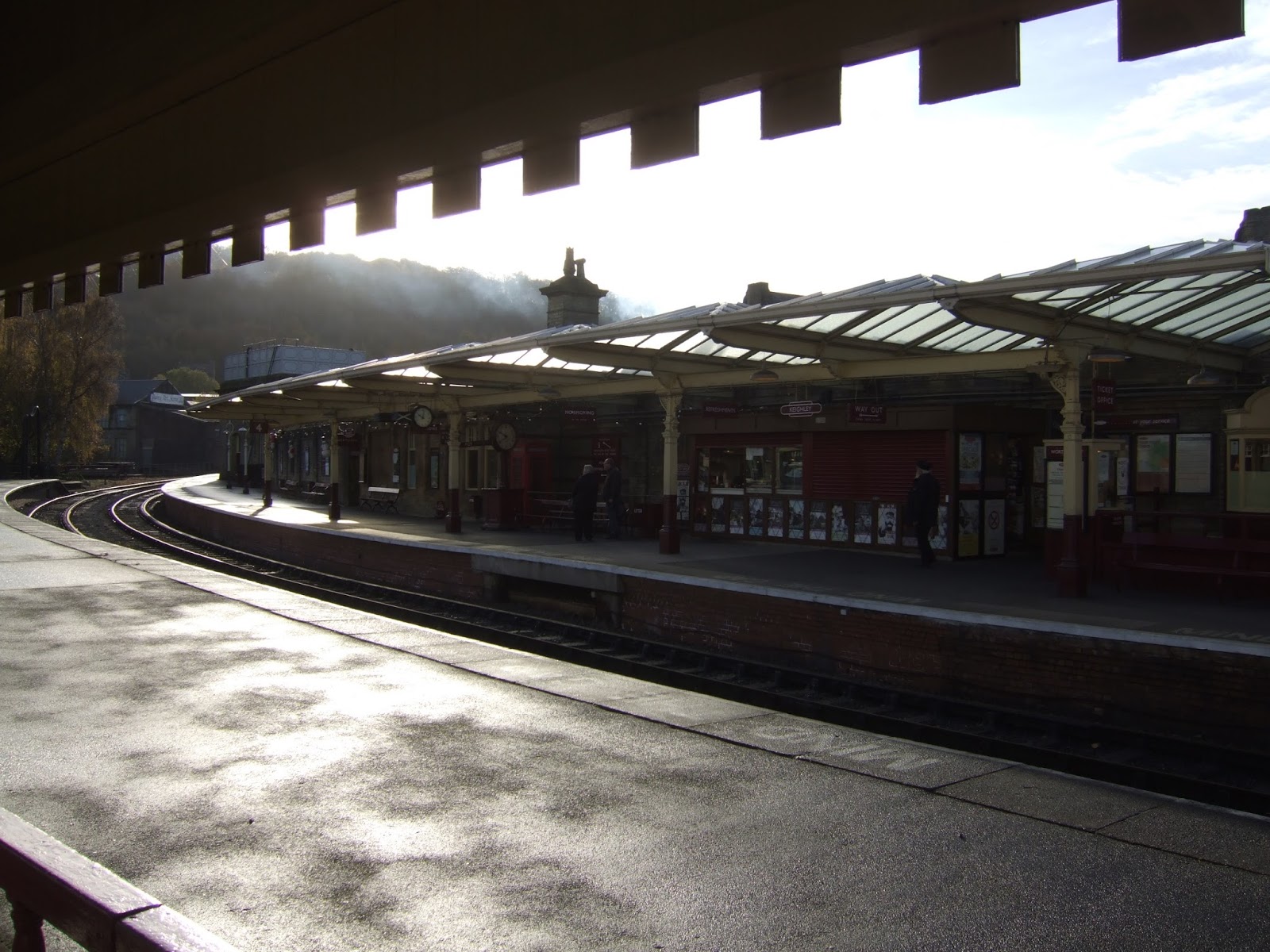
Well, I'm happy to say that we've made it to the final weekend of the 2017 walking season, having had worries that we might not get here after the physical and emotional beating that I've taken over the last few weeks, but my fortitude has held strong and gotten me out every weekend through the fading days of October and November, so my planned finale can run on the day allocated to it, and what's more the sun is expected to shine on it, so let's give Season #6 the ending it deserves. After doing most of the season in Bradford and the lands north of the Wharfe, Airedale seems the most apt place to conclude this year's trekking, midway between the two, and a sub 10 mile day doesn't require the earliest of starts, arriving at Keighley at 10am, to look to the K&WVR platforms and not that they've already been running for an hour by now, and wonder why I've never asked friends of colleagues out for a social occasion on this most lovable of preserved lines. Emerge into the crisp morning, that's going to feel like early evening all day as the sun never gets that high, to take a right turn out from the station, to admire the backdrop of Rombalds Moor before turning onto Dalton Lane to get the flavour of the towns commercial and industrial quarter, where there's still a lot of business going on around Dalton Mill, that large and dynamic structure that really ought to be at the heart of Keighley's civic pride and industrial heritage. The lane leads on, over the River Worth and on to meet Thwaite's Bridge, passing over the railway and the site of a former MR station that the internet seems to have no visual record of at all, before we split left, past the yard with a steam crane in it, to hit the ascent of Thwaite's Brow Road, a steep, cobbled and very minor road that twists sharply up the bank on the south of the Aire, offering a test for the legs and some fine views into the valley as we go up, encountering more descending traffic that I'm honestly happy with as we go. The views are worth the effort, though and the scattered houses of Thwaite's Brow give the road a bit more purpose as it winds on uphill to meet the terminus of the bus that serves it and Long Lee, beyond where the road gets a bit more normal and the houses a bit more suburban and ordered, still not sure why people might be drawn up onto a hillside like this but you start to ponder that once development space runs out down in the valley, up on these hills is the next obvious place to go.
 |
| The K&WVR platforms, Keighley Station. |
 |
| Dalton Mill, Keighley, always worth a look. |
 |
| Thwaite's Brow Road, steeply rising out of Airedale. |
 |
| Thwaite's Brow, Keighley's high suburb. |
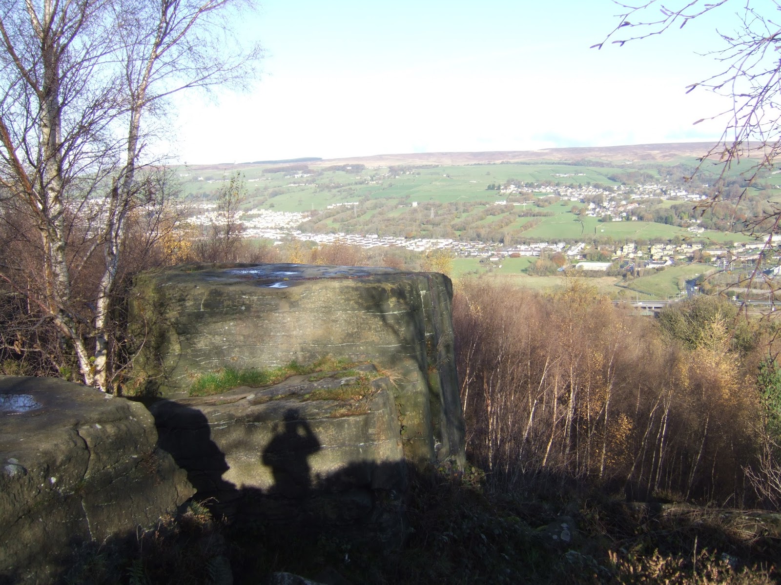
There's a lot of suburbs up here, surrounding the pub the Dickie Bird, and away from the semis we finally find the remnants of the rural settlement on Moss Carr Road, only a field or two distant from the road through Long Lee, now available to anyone who'd like to own a country house with a fine elevated view of Rombalds Moor, with the stepped edge of Rivock prominent, with sightlines to much more distant hills up the Aire on a clearer day. As the lane ends, we can pluck my ancient E288 out of the bag for its last hurrah, after six years of abusage, to follow the paths as they lead out high above the Aire valley, with cows for company as the track follows the long wall, with the bovines acting docile at long last, while the panorama over Riddlesden and East Morton is the feature in the valley as views towards Keighley recede. Crest at about 250m altitude at Transfield Top, pretty close to the St Ives estate, but our path is going to lead us downhill across the fields to the top edge of the steep slope that stretches all the way between Keighley and Bingley on this side of the river, into the woodland fringe, where birch seems to rule the day, and the leaf cover is sufficiently thin to give views downhill, that show us to be alarmingly high up, around 100m above the valley floor. Good to see the path is popular enough, as this is the sort of weather you want at this end of the year, and we draw on eastwards, as a ridge walk is always fun, but even better when you have a rock outcrop to find, like Druid's Altar, a group of high flat topped blocks of Gritstone right on the edge of the escarpment, offering a view across to Morton and the moor and down to the traffic island between Riddlesden and Crossflatts. A quietly wonderful little corner, a good spot for elevenses, and to attempt the climb atop the rocks to get a view down the steepling drop, not possible on the Altar Stone, and just a bit too alarming on the other, with the tops being cold and damp, again seen at the best sort of time of year, with the foliage cover at a minimum and beautifully lit. The next target for the day is viewable through the woods to the east, as Baildon Hill looms over the valley, but as it sits on the north and we're still on the south side, so we have a descent to come, so tracks are made towards Altar Road, which seems to attract people and riders who wish to tour the St Ives estate, and it's a lovely and shaded walk down the estate boundary and under the cover of the trees of Hollin Plantation, with the first open view directing us straight towards Idle Hill, another of this years sentinel constants, way off to the east down Airedale.
 |
| Moss Carr Road, Long Lee. |
 |
| Rivock and Riddlesden, from Transfield Top. |
 |
| Above Altar Woods, looking towards Micklethwaite. |
 |
| Druid's Altar, looking towards Morton, and the moor. |
 |
| Altar Lane, through Hollin Plantation, by the St Ives estate. |
The main revelation of the trip, appearing just below the tree cover as we follow the lane and the row of pylons steeply downhill, is that of Bingley, that town that just keeps avoiding appearing on my travels, only encountered three times so far in my first six walking seasons, and its appearance from up her is pretty dynamic, especially with the Damart factory rising above the centre of the town, and the flight of Five Rise Locks rising its way up the 17 mile pound on the Leeds & Liverpool canal. Also plain is the huge spread of suburbs to the north of the town, including the spread up above onto the high plateau of Eldwick, illustrating that many towns in Airedale had no trouble at all spreading up to moorland altitudes when the valleys got filled, something to chew on as we descend down through the wood and the lanes to the farms along the south side of the river. All the days height is shed by the time we run out onto Harden Road by the Brown Cow, and then pass over the Aire via Millgate bridge, one of those crossings that's too historic to be replaced by honestly too narrow to be useful in the contemporary world, but that doesn't stop it being busy, unlike Old Main Street, which has been largely cleared of traffic as it passes around All Saints church, worth a second look before we make a second passage across Bingley. Join the footbridge that leads from Keighley Road over the railway line and the A650, to the canal bank by the Three Rise Locks, marvelling at how the Airevalley Road got squeezed between the two, and we pass over the watercourse to pass behind the Damart factory and before the Italianate warehouse to run out past the modest terraces and soon meet the smart edge of Victorian Bingley on Park Road. The aim to Baildon Hill starts next, and to get up to height once again means travelling uphill, with the main road passing the best face of the suburban town before we reach the 20th century border and head up though the semis, getting one really good look back to the town, and over the hills of Alpine Bradford to Ovenden Moor, all in one angle, before the road swing eastwards to meet the bottom of Prince of Wales Park. The real elevation of the day comes along Parkside, as the road rises around the park steeply, which makes sense as we are passing around and over the rise of Eldwick bank, glimpsed down the footpath passing along it, and once again the mind ponders that such a settlement is a fine place when enjoying fine weather and the availability of motor transport, but is a whole less appealing without them.
 |
| The panorama of Bingley, Eldwick & Baildon Hill. |
 |
| Millgate Bridge, Bingley's crossing of the River Aire. |
 |
The A650 Airevalley Road, somehow squeezed between
the Leeds & Liverpool Canal, and the Leeds to Skipton railway line. |
 |
| Park Road, Bingley, with Victorian Suburbia. |
 |
| Parkside, with the ascent to Eldwick that you should have seen coming. |
Still, the suburb and village of Eldwick definitely has vintage, its village sign prominently declaring its 9th century name of Helguic, and on the eastward track of Otley Road, there are a lot more terraces and houses of a certain age that might have been expected in a suburb that grew mostly after the 1960s, and you soon get the sense of being 200m up as the mass of Baildon Moor looms in the distance, but views down to Airedale are sadly not forthcoming down the suburban roads, as we are too far removed from the bank edge. Meet the heart of Eldwick by its parade of shops, up from the pub, the Birches, the Memorial hall and the modest parish church, used multidemoninationally, , passing on to the edge of the village as we meet the War Memorial (on Remembrance Day!), and pass the old Wesleyan Chapel as the lane sweeps down to and over Eldwick Beck, one of the branches up from Shipley Glen, where the Acorn Inn is located and a small rural idyll endures around the water powered mill down in the valley. Lose the footway as we join Spring Road, and the lane gets narrow and twisty as we slip out among the farmsteads, alarmed at the quantity of traffic on this modestly scaled lane, and so wits have to be kept sharp as site of our destination looms, with Baildon Hill rising before us, and views down into the Aire valley finally arrive to the south and west, with attention also being drawn up towards Bingley Moor and the farmed landscape seen when walking the Dales Way link, met as we cross Glovershaw Beck. Pass the farm that still boldly offers 'TEAS' and hammer the lane up to the cattle grid that accesses Baildon moor, spread as a mass of yellowing grass to the north and east, glowing golden in the afternoon sun, and we hit the late season moorland walk to get to the top of Baildon Hill, not immediately visible as we start up, but the bridleway path leads to a direct route that a little bit of prior discovery indicates goes straight up to the summit. There's two steep rises, with a relatively flat plain between, with the going being especially friendly for November, passing over the track to the Dobrudden Farm caravan park, which covers most of the 70m of ascent from the road, getting a host of landscape revelations as we go, back over Eldwick to the woods of the St Ives estate and Druids Altar, and over to Chevin and the hills beyond Wharfedale. A fine place to conclude the 2017's season, as so many of the passages and destinations of the season can be seen, with a full 360 degree panorama revealed as we hit the top at 282m, my second journey up here, but my first with so much sunshine, a true blessing this late in the season.
 |
| Eldwick village, older than your average suburb. |
 |
| Baildon Hill from Spring Lane. |
 |
| Baildon Moor, viewed from the Hill ascent. |
 |
Today's path travelled, looking up Airedale
from the Dobrudden Farm track. |
 |
| Baildon Hill Summit, bathed in November sunshine! |
View the observational compass, do the panorama from the trig pillar and pause for a late lunch whilst I have the top to myself before it gets too cold and busy to linger at the summit any longer, striking south as attention heads towards the views to Leeds and Bradford, and all points in between as we head over the high plateau, for a surprisingly long way until we drop steeply down the sharp end of the hill to meet the bridleway to Hope Farm. Back at farming altitude and following the lane towards Baildon, the views are just aces as we can look across the Bradford, sat in its valley, and also trace Thackley, Idle and Wrose Hills, Shipley and Saltaire, and even Cottingley in the panorama of the Aire Valley, a grand sight to see from many angles as we run in past Dove Hall farm and then drop down to Baildon's suburbia-at-altitude. I think I've already sais everything there is to say how this happens in Airedale, seeing it at Keighley and Bingley too has just made Baildon's spreading onto the moor and above the Bank seem that bit less weird, but even then whilst the declining Hope Lane and Greencliffe Avenue seem desirable enough, the mind tells me that the surrounding wild landscapes could have them feeling rather remote. Meet the top edge of Baildon Bank, where the contours pack tight on the virtual cliff, but the switchback path down its face is not too far along the top edge path, where the steps and recently rebuilt paths take a whole bunch of altitude off our day, and we can still wonder how people are still so happy to live by this mass of exposed Gritstone, and we get a late route choice as we finally hit the bottom at Green Road. We won't be making for a conclusion in Saltaire, as the day's sunshine and warmth have passed and we need both for more photography there, so paths between the houses are sought to take us down to meet the B6151 Baildon Road, but instead of striking straight for the station, a short detour is in order up Hallfield Drive to see Baildon Hall, a building well hidden by the big suburban semis, but the original manor house of the parish, built in 1553 and in use as a private members club, worth visiting now as it's not otherwise visible from any of the surrounding lanes. Back to Station Road to put the hammer on to the finish line, still marvelling at the sheer strangeness of Baildon's development as two centuries worth of houses pile up chaotically, and taking views over to Idle Hill, which I still hope to summit one day, landing at the station at 2.30pm, just as the late running train arrives, concluding season #6, and 2017, exactly where I wanted to, my first time on an odd numbered year!
 |
| Above Hope Farm, looking towards Bradford. |
 |
| Hope Lane, Baildon's suburbia betwixt moor and bank |
 |
| Looking towards Baildon town from the Bank |
 |
| Baildon Hall, the 16th century manor house, hiding in the suburbs. |
 |
| Baildon Station, Season #6 & 2017's finish line. |
5,000 Miles Cumulative Total: 3108.5 miles
2017 Total: 543.5 miles
Up Country Total: 2832.9 miles
Solo Total: 2852.2 miles
Next Up: 12 weeks of Hibernation, and pondering what we've learned in 2017.


No comments:
Post a Comment